
Cycling stress map helps bikers avoid tricky streets
By charting biking angst, this Maryland county created a clever planning tool for safer streets While planners push the ideal of shared streets that are safe for every mode of transportation, city cyclists (as well as pedestrians) know most areas offer far from an idyllic commute. For many riders, sharing streets means constantly watching out for cars, and during trips to new neighborhoods, divining which routes are low-volume and more importantly, low risk.
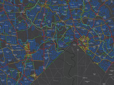
One county in Maryland decided that the best way to help stressful cyclist would be to turn that angst into some sort of action. The idea led Montgomery County to create a first-of-its-kind bicycle stress map, a colorful new tool to help riders plan routes, and planners focus on the most effective areas for attention and upgrades. As more cities focus on upgrading cycling infrastructure, tools like this, sort of a Waze for bicycling angst, can help push data-driven decision making that doesn?t break the budget. ?It?s a great way to engage the public and advocate for different biking infrastructure improvements with policy makers.? says David Anspacher, a transportation planner for the suburban, Washington, D.C. county. So great, in fact, the American Planning Association presented the project with an award at the group?s annual conference earlier this week in New York City.
Cyclists in Montgomery County
To create the map, researchers and planners looked at 3,500 miles of road in Montgomery Co...
| -------------------------------- |
| ELEMENTOS DEL CILINDRO |
|
|